 With today’s technology and with everyone having GPS at their Fingertips knowing basic map reading skills has become somewhat of a lost art. But what do you do when the grid is down and your GPS becomes an expensive useless brick weighing down your bug out bag?
Knowing how to use a map with a compass is not only useful while you are out in the wilderness, but it could turn out to very useful in a bugging out situation or if you are trying to avoid certain “danger zones” if the S were to hit the fan.
If you have a map, a baseplate compass and a pencil in your bug out bag (and know how to use them) and you can see two prominent land features you will never get lost again.
We created a course that goes into much more detail at the Survivalist Prepper Academy as well as using mother nature to find direction and how this not only applies to a wilderness setting, but an urban shtf scenario also. Click here for more information.

Before I get into how to triangulate your position on a map I want to go over a few of the basics of using a map with a baseplate compass so this all makes sense.

The image above shows you the different parts of a baseplate compass. Let’s start by explaining what some of the important features are. Don’t worry, these will make more sense as you read the article.
Magnetic Needle: The red end of the needle will always point to magnetic north. Magnetic north is different from true north (see Declination adjustment below.)
Rotating Bezel: This rotating wheel gives you the ability to set your bearing on a compass. This is what confuses most people about a baseplate compass, but hopefully it will make sense by the end of this article.
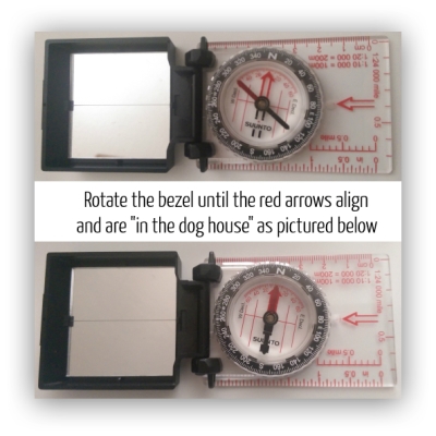
Declination Arrow: This is also referred to “the dog house” and is important to getting an accurate reading on your map.
Declination Adjustment: the magnetic needle gives you a reading of magnetic north, but depending on where you live true north will be off a few degrees, this is called declination.
Meridian Lines: These are used to align your compass (north and south) to the meridian lines on your map.
Scale: For this instance the scale is not all that important, what is important is the straight edge along the side so you can draw a line from point A to point B.
How to find your position on a map

Above is the Topographic map of the region we are going to discuss below. I will be going into detail about how to read a topographic map in the near future but for now let’s use some maps that are a easier to understand.
You can find any topographic map you like at MyTopo.com

Find your location
To do this you are going to have to be able to find at least two prominent features (point A and point B) in your line of sight and match those to your map. The best way to do this is get to the highest point possible with a clear view of the area. You will also need to be able to match these two points on your map.
This is where a topographic map comes in handy because it is more detailed and you can use smaller reference points like structures, smaller peaks or ridge lines.
You will probably have more detail on your map than the picture above, but for the sake of this article I had to use a zoomed out view.
Once you find your two points to use as reference points you can now grab your compass and start to plot your position.
1. To do this you need to point your compass with the “direction of travel arrow” pointing at object A that you picked out earlier.
2. Next move the “rotating bezel” until the red arrow is in the dog house to get your bearing. Make sure the compass is completely level to get an accurate reading.
3. Now we need to adjust your magnetic declination using the “declination adjustment” scale on your compass. Your declination will be shown on most maps, if it’s not you can easily find your declination here. Ours here in Colorado is 8 degrees E, so I would move the bezel an additional 8 degrees to the east.
To learn more about magnetic declination watch this video.

4. Now take your map and place the inside line of the compass on point A
5. Move the compass (not the bezel) until the north/south meridian lines on the compass line up with the north/south lines on the map. If your map does not have meridian lines just line it up as even as possible with the map.
6. Now draw a line from point A down the straight edge of your compass baseplate ensuring you are lined up north and south and your compass is still on point A
7. You now know you are somewhere along this line. To find your exact location follow steps 1 through 6 using point B to take your next bearing.
Once you have your second bearing mapped out, the place where the two lines intersect is you location.

You would probably be able to find your way without using a baseplate compass, but by pinpointing your location you will not only save time by knowing the exact direction to travel you can also avoid areas that might be difficult to travel through, or areas you want to avoid.
In the image above you can see that by traveling north a little bit you will find a stream that leads to a road that you can follow to your destination. This route will be far easier to travel than going in a straight line like a GPS would take you because a straight line could lead you through glaciers, up a mountain side or through any sort of enemy SHTF camp you were hoping to avoid.
I am currently working on a course at the Survivalist Prepper Academy that will go into more detail about topographic maps, primitive navigation and living off the grid skills. I will also update this post when I get the video done in the near future.
If you have any questions about this please leave a comment below and I will try to answer them.
Visit MyTopo.com here and get a topographic map of your area.
Discover more from Survivalist Prepper
Subscribe to get the latest posts sent to your email.
3 replies to "How to Use a Map and Compass – Never Get Lost Again"
Great info as always Dale. Thank you
Sharing it, brother! One of my skills to learn this year is low-tech navigation with compass and topo map. Thanks for the excellent tutorial. Looking forward to practicing.
Thanks Todd, Keep up the great work at SurvivalSherpa, It’s one of the best around IMO.